MANASLU TREK WITH LARKE PASS KATHMANDU
City: Kathmandu (Nepal) Latitude: 85.33333 Longitude:85.33333 Id: 146482 -S:1037
Free Cancellation
")
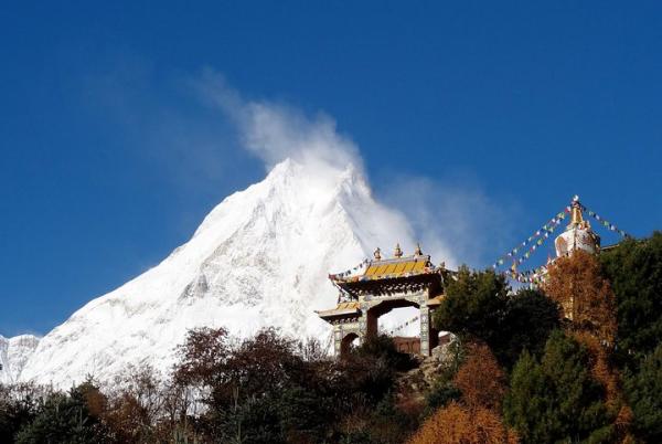
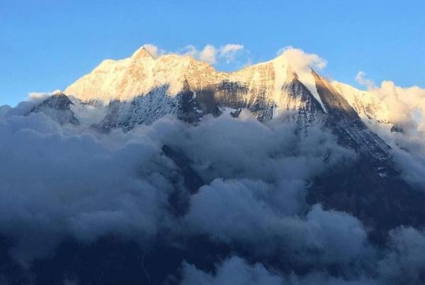
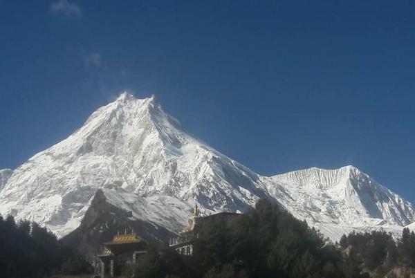
Manaslu is unique trail that follows upstream of Budi-Gandaki River leading from the sub-tropical forest to the dry arctic zone and high Tibetan climatic zone with magnificent views of worlds 8th highest Mt. Manaslu at 8,163m, including spectacular views of the other closest peaks that straddles the border with Tibet. This beautiful trekking route was first opened on 1991 and still the route is restricted for individual travelers and without special immigration permit issued by Nepal Immigration. Manaslu Larkey Pass Trek takes you to the popular old Gorkha Kingdom in the midwest Himalayan range of Nepal.
Manaslu is a restricted-region and also needs a unique permit from Nepal Government and Licensed guide for a trek. After the highest point of Larkey La, the downhill way leads through the excellent timberland of pines, rhododendrons, oaks and magnolia trees. The trail finally meets the Annapurna Circuits Trail after reaching to Dharapani.
.
*One per booking
Adult : from 18 to 60 : from 1 to 15 Persons
For a full refund, cancel at least 24 hours before the scheduled departure time.
Check Availability
Additional Information
- Travelers should have at least a moderate level of physical fitness
- Day 01 : Arrival in Kathmandu [1,300m/4,264 ft]
- One of the representative from HSA will pick you up from the international airport and take you to the hotel
- Day 02 : Kathmandu Valley Sightseeing and Trek Preparation.
- After having breakfast in the morning at around 9 AM you will be Proceed on to Pasupatinath Temple ,Boudhnath Stupa ,Patan Darbar Square and Swayambhunath Stupa. Swayambhunath is a Buddhist Stupa said to be more than 2000 years old,
- Day 03 : Kathmandu to Soti khola by Jeep/ Bus 7 - 9 hours
- Early morning 6 to 8 hours drive to Aarughat. Aarughat is a famous shopping area for Manaslu Gorkha and Dhading’s remote villagers.Drive then continues to Aarkhet Bazaar.Overnight in Aarkhet Bazaar.
- Day 04 : Soti to Machhekhola
- After breakfast, trek starts following the Budigandaki river, climbing briefly to Kyoropani, path descends once again to the river at the confluence with the tributary of Soti Khola. We pass a number of small villages, tucked into the hillside, until we reach a widening of the valley, opposite the point where a large tributary stream enters the Buri Gandaki. The terraced farmland here belongs to the village of Lapu Besi. Treks descend once again to the wide, sandy riverbed and follow a path, which runs below the steep, craggy valley side. At length, we have to climb up once again on a trail to Machhekhaola 1300m,Machhekhola means “Fish stream”.Overnight in Machhekhola
- Day 05 : MachheKhola to Jagat
- We cross the MachheKhola , head upstream to the tiny village of Khorla Bensi and the hot springs at Tatopani (hot water). The valley sides steepen until they are impassable and the route then switches to the left bank by way of a suspension bridge. The trail is quite exposed and challenging in places. After a short section of forest path we reach the single tea house at Doban. Above Doban, the Buri Gandaki descends an impressive series of rapids. Beyond this steep section, the river is much more placid, meandering across a broad gravel bed. At Lauri, we re-cross the river on a suspension bridge and then climb on a high path to the fields of Jagat 1360m.Overnight in Jagat.
- Day 06 : Jagat to Deng
- After descending a long series of stone steps to the river, treks climb a terraced hill to Saguleri, from where we can see the impressive Sringi Himal 7187m. Crossing Buri Gandaki River again at Gatte Khola, our route continues upstream, through a gorge section with towering walls. We cross the river three more times in the next two hours to avoid difficult valley sides and then climb up over a further steep spur to reach the village of Deng 1800m.Overnight in Deng.
- Day 07 : Deng to Bagarchap 2300m
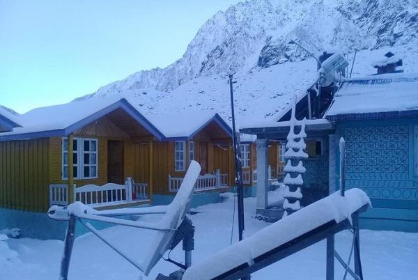
- The valley is still steep- sided and most impressive. We cross to the village of Lana, and start to see Mani stones, a sure signs that we are entering high country Buddhist regions. After only about four hours we reach overnight place at the village of Ghap, which straddles the river. We have entered the Tibetan areas and the cultural change is obvious, and the climate change is also obvious the trekking is pleasantly cool now, as we start to fain the altitude 6 hours, overnight in Bagarchap.
- Day 08 : Bagar/Ghap to Namrung
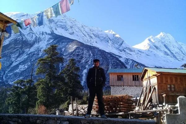
- We gain altitude to take us into alpine territory and increasing mountain views. There are more Mani walls and 3 more crossing of the Buri Gandaki on our route to Namrung 2550m, where our permit is checked too. Above this village the valley opens out and there are extensive pastures. Climb gently now, and cross a large stream flowing down from the Lidanda Glaciers, and reach the Tibetan village of Sho or Syanjang, cross the river again than to reach Namrung, overnight stay in Tea house. Just above the village we get our first incredible views of the Manaslu North.
- Day 09 : Namrung to Samagaon 3360m
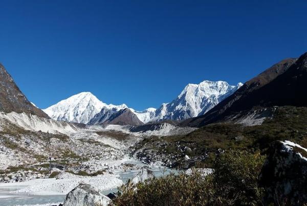
- We pass Lho, a large village at 3150m where there is a lovely little monastery and numerous Chortens and Manis. Looking back Ganesh I is visible. Leaving the village, we follow the right bank of the river, with views of Peak 29 ahead. At a fork in the trail, we take a detour to the left, which leads up to Honsansho Gompa and the Pungen Glaciers, from where there is a stunning view of Peak 29 and Manaslu. Leaving the village of Lhogau, you follow the right bank of the river, with views of Peak 29 ahead. As you continue on the main trail, you soon reach the fields of Sama Gaon, 3500m.Overnight in Sama Gaon.
- Day 10 : Acclimatization rest in Samagaon
- This is a day for rest at Samagaon to give you some acclimatization. Surrounded by mountains in a peaceful forest, you take a breather to acclimatize and relax. You can hike to Manaslu Base Camp for excellent views of Samdo (Pang phuchuli); Nagdi chuli, Simnang Himal, Manaslu glacier, Manaslu ice fall and you can see Birendra Kunda which is an ice lake nearby the Manaslu Base Camp.Overnight in Sama Gaon.
- Day 11 : Trek from Samagaon to Samdo (3690m)
- You trek gently uphill all the way to Samdo through a desert path and windy valley. The Tibetan border is just four kilometers away from Samdo, but visitors are not allowed to pass the border. There is a Tibetan refugee village at Samdo. This is an excellent view point for Mt. Manaslu, Samdo (Pang phuchuli), Nagdi chuli, Simnang Himal, Manaslu glacier, Manaslu ice fall and several other majestic peals.Overnight in Samdo.
- Day 12 : Trek from Samdo to Larkya La Phedi (4460m.)
- Dharmashala or Larkya Phedi takes about 4/5 hours. The trail is rocky and zigzags all the way to your destination. Before you reach Larkya Phedi, there is a market called Larkya Bazaar (market) where seasonal fairs are held for the local folks. People bring goods from Tibet to sell it here.Overnight in Dharmasala.
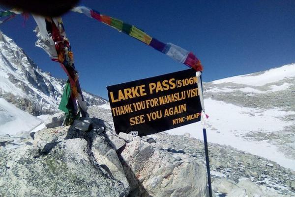
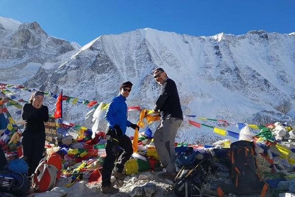
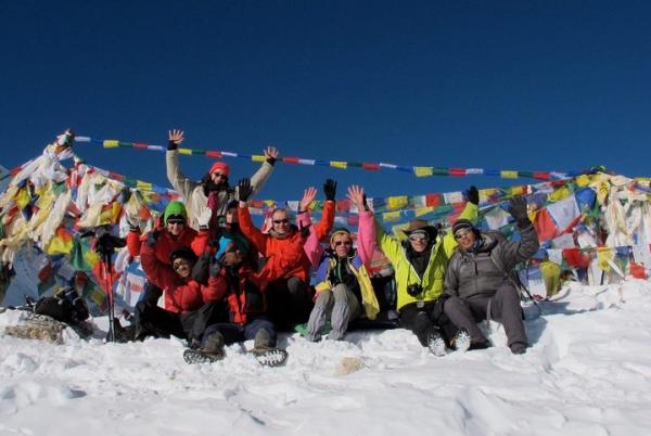
- Day 13 : Trek from Dharmasala to Larkya La (Pass) 5135m to Bimthang 3590m
- It takes about 7/10 hours. Early in the morning you begin to trek a steep ascending path until Larkya La through a rocky and windy trail. Today you carry a packed lunch. From the top, you can enjoy the views of Larkya peak, sunrise at Mt. Manaslu, Ratna chuli, Cheo Himal and many other snow capped mountains and peaks. Crossing this pass, you hike to a steep downhill path through rock and ice. On the way, you will encounter many icy lakes. Bimthang is a broad and level ablation valley with a number of Mani walls and deserted houses. Overnight in Bimthang.
- Day 14 : Bhimtang to Tilije 2360m
- Trek from Bimthang to Tillje takes about four/five hours. Crossing this high pasture, you descend the valley of the Burdin Khola to the area of the Base Camp for the West side of Manaslu. From a ridge at 4150 meter, you have excellent views of Manaslu to the South East and Annapurna II to the South West. Beyond a bridge over the headwaters of the Dudh Khola, you descend into a rhododendron forest and follow a trail through a narrow valley until you reach the highest cultivated land in this valley at Karche, 2785 meter. Walking down you cross a stream to reach Tilje. Here is an apple orchard which is quite famous for local wine.Overnight in Tilije.
- Day 15 : Tilije to Dharapani 1860m
- Leaving Tilje, you trek uphill for nearly 45 minutes to reach Dharapani crossing a bridge over the Marshyangdi River.Overnight in Dharapani.
- Day 16 : Dharapani to Besi Sahar
- We walk down until Syange 3/4 hours and take Jeep/Bus to Besi sahar 2/3 hours, overnight in Besi Sahar.
- Day 17 : Besi Sahar to Kathmandu drive by local bus 4/5 hours
- After breakfast we drive to Kathmandu. We take you for a cultural dinner in the evening.
- Day 18 : Departure Day
- Our Driver will transfer you to the International Airport 3 hour earlier to connect the international flight.
Tickets
*Mobile or paper ticket accepted*One per booking
Prices
* Per PersonCancellation Policy

Contact Us
- +971566917141
- +97143887001
- Send a Message
You may also be interesed in in Kathmandu


Featured attractions in Kathmandu

Bodhnath Stupa
Bodhnath Stupa Virtual tour to Bodhnath Stupa Where you can serach for maps, photos, videos, distances, and other infor
Bodhnath Stupa Virtual tour to Bodhnath Stupa Where you can serach for maps, photos, videos, distances, and other infor

Kashtha Mandap
Kashtha Mandap Virtual tour to Kashtha Mandap Where you can serach for maps, photos, videos, distances, and other infor
Kashtha Mandap Virtual tour to Kashtha Mandap Where you can serach for maps, photos, videos, distances, and other infor

Indra Chowk
Indra Chowk Virtual tour to Indra Chowk Where you can serach for maps, photos, videos, distances, and other information
Indra Chowk Virtual tour to Indra Chowk Where you can serach for maps, photos, videos, distances, and other information

Dhum Varahi
Dhum Varahi Virtual tour to Dhum Varahi Where you can serach for maps, photos, videos, distances, and other information
Dhum Varahi Virtual tour to Dhum Varahi Where you can serach for maps, photos, videos, distances, and other information

Jagannath Temple
Jagannath Temple Virtual tour to Jagannath Temple Where you can serach for maps, photos, videos, distances, and other i
Jagannath Temple Virtual tour to Jagannath Temple Where you can serach for maps, photos, videos, distances, and other i

Ashok Binayak Temple
Ashok Binayak Temple Virtual tour to Ashok Binayak Temple Where you can serach for maps, photos, videos, distances, and
Ashok Binayak Temple Virtual tour to Ashok Binayak Temple Where you can serach for maps, photos, videos, distances, and

Goorakhnath
Goorakhnath Virtual tour to Goorakhnath Where you can serach for maps, photos, videos, distances, and other information
Goorakhnath Virtual tour to Goorakhnath Where you can serach for maps, photos, videos, distances, and other information

Asan Tole
Asan Tole Virtual tour to Asan Tole Where you can serach for maps, photos, videos, distances, and other information abo
Asan Tole Virtual tour to Asan Tole Where you can serach for maps, photos, videos, distances, and other information abo

Swayambunath Stupa/Monkey Temple
Swayambunath Stupa/Monkey Temple Virtual tour to Swayambunath Stupa/Monkey Temple Where you can serach for maps, photos,
Swayambunath Stupa/Monkey Temple Virtual tour to Swayambunath Stupa/Monkey Temple Where you can serach for maps, photos,

Ikha Narayan Temple
Ikha Narayan Temple Virtual tour to Ikha Narayan Temple Where you can serach for maps, photos, videos, distances, and o
Ikha Narayan Temple Virtual tour to Ikha Narayan Temple Where you can serach for maps, photos, videos, distances, and o

Maju Deval
Maju Deval Virtual tour to Maju Deval Where you can serach for maps, photos, videos, distances, and other information a
Maju Deval Virtual tour to Maju Deval Where you can serach for maps, photos, videos, distances, and other information a

Narayanhity Dubar
Narayanhity Dubar Virtual tour to Narayanhity Dubar Where you can serach for maps, photos, videos, distances, and other
Narayanhity Dubar Virtual tour to Narayanhity Dubar Where you can serach for maps, photos, videos, distances, and other
Receive our newsletter with the best offers!
 European euro
 Saudi riyal
 UAE dirham
 United States dollar
We are now looking for the best deals Kathmandu

